TOLKMICKO TOWN AND COMMUNE COUNCIL
82-340 Tolkmicko, ul. Portowa 2
tel.: (055) 2316127
Chief of local authority
Mayor ZBIGNIEW GZOWSKI
Controlling maritime authority
TOLKMICKO
BOATSWAIN'S OFFICE
ul. Parkowa 1
82-340 Tolkmicko
Contact of maritime authority
Harbour Boatsman
Maria Kozłowska
tel. (055) 2316614
Harbour radio
VHF Channel 16
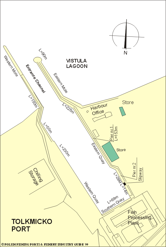
Navigational aids:
Tolkmicko Leading Lights through the approach fairway, marked by
buoys, from TOL Light-boy to the harbour entrance. The fairway
which is 40m in width, has depth of 2.0 to 2.5m. The entrance
channel is approximately 30m wide. Tolkmicko Light (white mast,
red band and gallery) is exhibited at an elevation of 7m, at the
head of Tolkmicko W mole.
Quayage and berthing facilities
The harbour basin is entered between two moles. The western mole
is 150m long and the eastern one is 90m long. The basin is
approximately 200m long, 60m wide and 1.4 to 2.5m deep.
General facilities
Fuel
Available.
Water
Available on the quayside.
Slipping
There is slipway for fishing boats.
Stevedoring
Available for live and wet fish.
Fisheries facilities
Ice
Production plant, capacity of 25t per day.
Cold storage capacity
Not available.
Chilling storage capacity
Chilling rooms, capacity of 50t.
Frozen fish transport
Not available.
Types and size of fishing fleet
42 fishing boats, mainly steel, with average length of 8.3m and engine power of 49 to 82 HP
Types of fish landed (in tonnes) (1995)
Herring
393.7
Eel
19.2
Perch
10.9
Sabrefish
8.9
Pike-perch
6.9
Bream
5.8
Roach
5.2
Lamprey
4.9
Smelt
0.9
Others
0.1
Total
456.5
Nearest airport:
Rębiechowo, approx. 100km
Other info:
Substantial part of caught eel has been exported to West-European
countries as an alive fish.
General information:
Tolkmicko is a fishing harbour and a health resort situated on the
southern shore of Vistula Lagoon. Population is about 2,830.
Originally it was a settlement inhabited by an old Prussian
tribe, the Warmians (Ermelanders). A massive fortified camp
built by them still exists. Having subdued the area, the Teutonic
Knights built a castle here, around which a settlement arose.
The first written record about Tolkmicko (known this time as
Tolkemit) dates from 1326. In 1350 it became a municipality and
was defended by a line of strong walls. While under Polish rule
(1453-1772) the town suffered destruction several times during
the wars with the Teutonic Knights and with Sweden. After the
partition of Poland, Tolkmicko fell under German rule (1772-1945).
From Tolkmicko the road runs through fine hilly country to Frombork.
Town is connected to the general railway system. There is a fishing
boats base and small boat building yard. The fishing harbour was
built in 1862-64. Before the First World War local fishing fleet
numbered 120 fishing boats. Nowdays it is the largest harbour of
Vistula Lagoon.
In the harbour basin Eastern Quay serves fishing boats and is
equipped with a boat slipway. There is Coastal Rescue Station
with a life-saving vessel which may also be used as a tug. She
is kept in readiness close NE of the harbour entrance, where
there is also a metal observation tower. Western Quay (presently
renovated) is used by passenger vessels. It was the only one quay
on Vistula Lagoon, equipped with a railway siding. Cargo barges
could moor at it. Tolkmicko serviced cargo ship traffic which is
seasonal connected with the lagoon icing. 2,120t of coal from
Russia was unloaded in Tolkmicko in 1996. The historical buildings
of Tolkmicko include a Gothic church from the 14th century and the
tenement houses from the 18th century.