SOPOT TOWN COUNCIL
81-704 Sopot, ul. Kościuszki 25/27
tel.: (058) 5511178, fax: 5512687
Chief of local authority
President JACEK KARNOWSKI
Controlling maritime authority
MARITIME OFFICE
IN GDYNIA
ul. Chrzanowskiego 10
81-338 Gdynia
tel. (058) 6202285, fax 6206743
Contact of maritime authority
Gdynia Harbour Master
Wojciech Oziemski
tel.: (058) 6202853, fax: 6200591
Harbour radio
VHF Channel 16
Navigational aids:
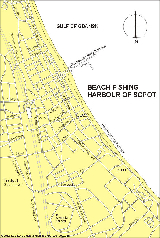
Sopot Light (54°26.8'N, 18°34.3'E) is exhibited from the prominent
white tower of the bathing establishment near the root of Sopot Pier.
St Jerzy Church, with a pointed tower about 3 cables SW of Sopot
Light, a hotel with a greenroofed cupola close NW of the root of
Sopot Pier and another tower near the foreshore, 0.5 mile SE, are
all good landmarks.
Quayage and berthing facilities
Sopot Pier extends 516m to seaward, a 150m long spur extends SE
from the pier. At Sopot there is a beach harbour for fishing boats,
in length of 160m.
General facilities
Fuel
Available.
Water
Available.
Slipping
Available.
Stevedoring
Available.
Fisheries facilities
Ice
Available.
Cold storage capacity
Available.
Chilling storage capacity
Available.
Frozen fish transport
Available.
Types and size of fishing fleet
7 fishing boats (length of 5 to 7m) and average engine power of 25 HP
Types of fish landed (in tonnes) (1995)
Flounder
62.9
Herring
13.1
Cod
11.8
Eel poud
0.6
Turbot
0.3
Eel
0.3
Perch
0.1
Others
0.1
Total
89.2
Nearest airport:
Rębiechowo, approx. 20km
General information:
Sopot is the town with a population about 47,800 situated partly on
a low coastal plane and partly on the high wooden sea coast in Gulf
of Gdańsk about 2 miles southward of Orłowo.
Sopot extends along the coast. The other natural border of the town
is provided by the wooded morain hills. Because of the Peninsula of
Hel shelters the Gulf of Gdańsk, the waters off Sopot's beaches are
warmer than those in other Baltic ports.
The site of Sopot has been inhabited for a very long time. Expeditions
of Roman merchants penetrated here, as archaeological excavations
prove. The name Sopot occurred for the first time in a document
dated 1283. About the mid-16th century there arose in Sopot the summer
residences of Gdańsk patricians. Since 1820 Sopot has been a widely
frequented seaside resort well known throughout Europe.
In 1909 the Forest Opera was created here, and performances held
every year. About 1920 a casino was established here. Sopot is
connected by road and rail with Gdynia and Gdańsk and in the summer
there is regular passenger ferry service with those and other places
in Gulf of Gdańsk.
This seaside resort is wellknown meeting place for the artistic
elite from both Poland and abroad and has become even better known
in recent years for its annual international song festival. The
city centre has many guesthouses and villas from the eighteenth
and the nineteenth centuries.
The fishing harbour is on the stretch of open beach, 160m long,
from which boats are launched and retrieved with an electric winch.
The catch is sold directly to local consumers or tourists from the
boats. Facilities located on the beach include storage sheds for
nets, outboard engines, fuel, and other supplies. There is storage
for chilled fish.