|
|
| Polish Ports - Крыница Морска |
| Local commune administration authority |
|
KRYNICA MORSKA TOWN AND COMMUNE COUNCIL
82-120 Krynica Morska, ul. Gdanska 69b
tel.: (055) 2476630, fax: 2476566
|
Chief of local authority
Mayor EDWARD BEDNARZ |
| Controlling maritime authority |
|
|
KRYNICA MORSKA
BOATSWAIN'S OFFICE
ul. Gornikow 85
82-120 Krynica Morska
|
Contact of maritime authority
Harbour Boatsman
Adam Ostrowski
tel. (055) 2476076 |
Harbour radio
VHF Channel 16 |
Navigational aids:
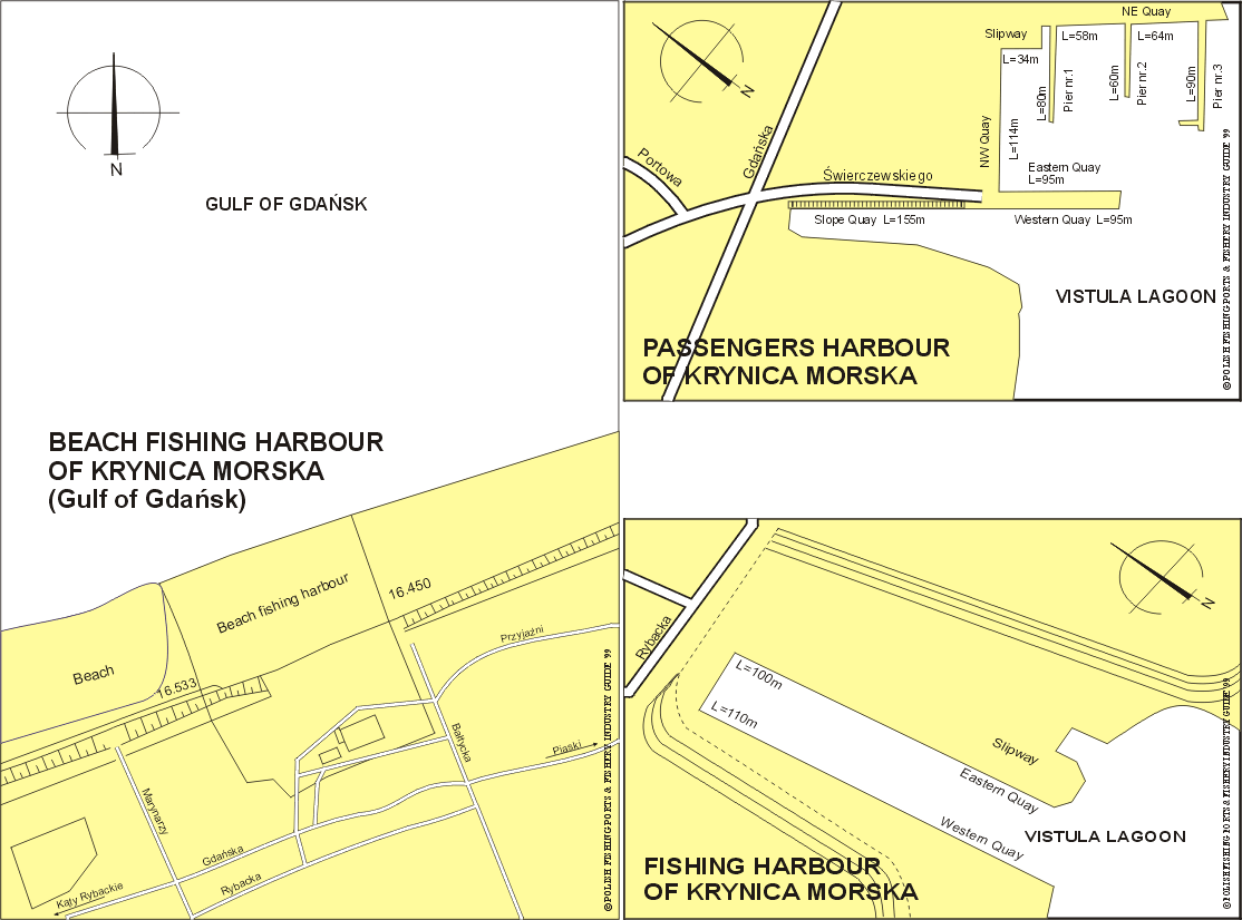
The access to Krynica Morska is from both side, from Gulf of Gdansk
and from Vistula Lagoon. Krynica Morska Light-house
(54°23.3'N, 19°27.0'E) a red round tower with a white lantern, 27m
in height. It stands on a sand dune near the coast. From the side
of Vistula Lagoon. The SE approach, leads NNE from TOL Light buoy
(red and white stripes with cross topmark), then the channel marked
by buoys (red spar). The S approach, leads NNE from Elblag Light,
marked by buoys and leading lights. |
Quayage and berthing facilities
From the side of Gulf of Gdansk, a dolphin stands close offshore
about 1 mile W of Krynica Morska Light-house and is used in
connection with beaching fishing boats. From the side of Vistula
Lagoon there are two harbour basins 1.5 cables apart, the E basin,
approached from the SE, is used by ferries, general traffic and yachts
and the W basin, approached from the S, is used by fishing boats. |
| Fuel |
Available. |
| Water |
Available. |
| Slipping |
At the entrance to the fishing basin there is slip for fishing boats. |
| Stevedoring |
Available. |
| Ice |
Production plant, capacity 10t per day. |
| Cold storage capacity |
Not available. |
| Chilling storage capacity |
Chilling room for 40t of fish. |
| Frozen fish transport |
Available. |
Types and size of fishing fleet
6 fishing boats (length of 5 to 7m) and average engine power
of 25 HP from the side of Gulf of Gdansk and 12 boats, mainly
wooden, average length of 6.7m and engine power of 29 to 52 HP
from the side of Vistula Lagoon. |
| Types of fish landed (in tonnes) (1995) |
| GULF OF GDANSK: |
| Flounder |
14.5 |
| Herring |
4.2 |
| Pike-perch |
3.2 |
| Salmon-trout |
0.3 |
| Bream |
0.2 |
| Others |
0.1 |
| Total |
22.5 |
|
| VISTULA LAGOON: |
| Pike-perch |
6.7 |
| Bream |
3.3 |
| Roach |
2.3 |
| Eel |
1.5 |
| Perch |
1.4 |
| Others |
0.2 |
| Total |
15.4 |
|
Nearest airport:
Rebiechowo, approx. 70km |
General information:
Krynica Morska is a fishing port and seaside resort situated on
Vistula Spit which is a narrow sandy peninsula between the waters
of the Gulf of Gdansk and Vistula Lagoon. Population is about 1240.
The first written information about a fishing village located here
comes from 1424. Krynica Morska, from 1991 a town, earlier a village
formed 1865 from the communes of Liep (13th century fishing village
on the Vistula Lagoon) and Kahlberg. There are inn from the 15th
century and a postal station established in the 16th century. From
1815 it was a holiday resort built by a steam ship consortium from
Elblag which promoted the construction of villas and manor houses
modelled on Greek architecture, which unfortunately did not survive.
In the second half of the 19th century the most popular type of
architecture was a cross between a Swiss moutain chalet and a
fisherman's cottage, today still to be seen along some streets.
After 1920 Krynica Morska lost its exclusive atmosphere. It was
then that fishermen's cottages with rooms to rent beame popular.
Major sights include: modern pension and villas, fishermen's and
summer cottages from 1850-1920, a lighthouse dating from 1951
(26,5m), and the Second World War cemetery.
From the side of Gulf of Gdansk there are wooden piers and beach
harbour, 83m long, from which Baltic fishing boats are launched and
retrieved with a winch. From the side of Vistula Lagoon there is a
port with two basins. The passenger - yacht basin complex consists
of 110m long and 18m wide passenger pier, and a yacht wharf. Krynica
Morska serviced tourist traffic. In 1996 - 87,853 passengers took
trips onboard ships of the "white fleet" (1,068 ship visits)
to/from Krynica Morska.
Fishing basin has W quay 110m long, E quay 100m long and N quay 22m
long with depth of 2.0 to 2.5 m. Fishing basin has been completely
rebuilt in 1992 and became a harbour with the best technical condition
on Vistula Lagoon.
Sometimes, the boats from the beach harbour are transported by lorry
to the port on side of Vistula Lagoon for fishing during the season. |
|