|
|
| Local commune administration authority |
|
HEL TOWN AND COMMUNE COUNCIL
84-150 Hel, ul. Wiejska 50
tel.: (058) 6750545, fax: 6750410
|
Chief of local authority
Mayor MIROSLAW WADOLOWSKI |
| Controlling maritime authority |
|
HEL HARBOUR
MASTER'S OFFICE
ul. Wiejska 24
84-150 Hel
|
Contact of maritime authority
Harbour Master
Marian Czech
tel.: (058) 6750618, fax: 6750618 |
Harbour radio
VHF Channel 16 and 12 |
Navigational aids:
Hel Lighthouse, a red 8-sided masonry tower, 38m in height, standsin a wood about 4.5 cables NNE of the S extremity of Hel Peninsula.Approaching Hel steer to pass at least 0.5 cable seaward of HL-Slight-buoy, which marks the southern edge of the steep to coastalshoal, altering course gradually NNW then NNE to the harbour entrance. |
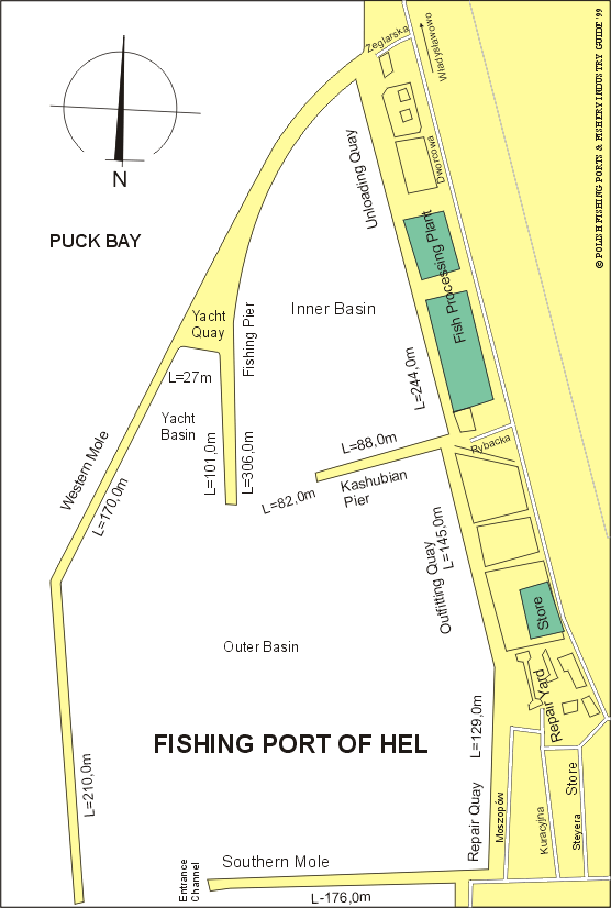
Quayage and berthing facilities
The harbour has two basins formed by two outer and two inner moles.The outer, western mole 560m long and the outer, southern mole 258mlong form outer basin. The entrance between the mole-heads is 85m inwidth and 8m in depth. The total length of the mooring line is 1630mwith depth of 4 to 8m. |
| Fuel |
Supplies of fuel oil are available 12t per hour. |
| Water |
Available on quaside 20t per hour. |
| Slipping |
Ship repair facilities are available, also small slipway. |
| Stevedoring |
The highest possible fish stevedoring at the port, is estimated at 20000t of fresh fish annually and day-long fish unloading at 350t. |
| Ice |
Tube ice production plant capacity of 80t per day. |
| Cold storage capacity |
Total capacity of 880t (one cold store capacity of 660t and second one capacity of 220t). |
| Chilling storage capacity |
Two chilling rooms, total capacity of 400t. |
| Frozen fish transport |
Available. |
Types and size of fishing fleet
26 cutters:
11 cutters (24m, 341 HP)
7 cutters (25m , 570 HP)
5 cutters (length of 17 to 19m and average engine power of 183 HP)
3 cutters (26m, 647 HP)
8 from above - mentioned cutters have conducted fishing for salmon and other salmonids.
10 fishing boats (length of 5 to 7m) and average engine power of 25 HP |
| Types of fish landed (in tonnes) (1995) |
| CUTTERS: |
| Sprat |
12525.5 |
| Herring |
2446.4 |
| Cod |
962.1 |
| Flounder |
66.3 |
| Salmon |
37.7 |
| Salmon-trout |
9.0 |
| Rainbow-trout |
0.5 |
| Perch |
0.3 |
| Pike-perch |
0.2 |
| Turbot |
0.1 |
| Others |
0.4 |
| Total |
16048.5 |
|
| FISHING BOATS: |
| Flounder |
19.0 |
| Cod |
0.5 |
| Herring |
0.4 |
| Salmon-trout |
0.3 |
| Eel |
0.1 |
| Eel-pout |
0.1 |
| Salmon |
0.1 |
| Rainbow-trout |
0.1 |
| Total |
20.6 |
|
Nearest airport:
Rebiechowo, approx. 94km |
Other info:
Freezing capacity of contact, plate sets 24t per day. |
General information:
Hel is an old fishing settlement located on the end of Hel Peninsulawhich became a town in times of prosperity, for the first time, thenmunicipal charter was granted as early as 1378. It is now a busyfishing centre and seaside resort with the population of about 4,800.Of the few relics the 15th century Gothic church and some quaintfishing cottages of frame construction have been preserved to this day.
Since the Middle Ages the population of Hel was engaged in the herringfishery. In the 12th - 14th centuries abundance of herring shoalsconstantly appeared on the fishing grounds near by Hel. At thebeginning of the 15th century herring resources were drasticallydepleted and the town went through hard times. In 1887 the decisionto construct the artificial fishing port at Hell was make.Construction began in 1892 and in the next year Hel was the basefor 110 fishing boats operating in the Baltic fishing grounds.
Between the two World Wars, Hel was an important centre of the Polishfisheries. In 1921 about 180 fishermen, registered in Hel, were theowners of 42 cutters and 175 motor/sail fishing boats. In the beginningof the 19 twenties, the first Polish maritime ichthyological centre wasestablished under direction of Professor K. Demel. It still exists asa branch of the Sea Fisheries Institute of Gdynia and its activitieseffects the entire fishing industry, including the catching, and themain threat to the coastal fisheries, enviromental degradation.The Museum of Fisheries at Hel was opened in 1961, located in the 15thcentury church, adopted for this purpose. The collection includesexibits connected with deep-sea fishing and navigation.At the end of Hel Peninsula is the lighthouse built in 1942.
The maiden deep-sea fishing voyage to the North Sea fishing grounds wasmade during September of 1938 by cutter "Hel-111", under command ofskipper F. Piechowski. After a 20 day fishing operation, the cutterlanded in Hel 60 barrels of salted herring and 140 boxes of freshherring chilled in ice. After the Second World War, in 1958 the fishingcompany KOGA was established.
Entry to the fishing harbour is situated from the side of the Bay ofPuck. There are two basins:
- the inner basin (for berthing and reloading) with depth of 4 to 5m.Near the basin fish processing plant and ice production plant arelocated
- the outer basin (for unloading and berthing) with depth of 5 to 8m,shielded by moles. It is significant that not only fishing vessels moorthere, but also passenger vessels and yachts.
The harbour is very convenient for the fishing fleet, due to locationin relation to the fishing grounds and a short icing period (theaverage number of days with ice cover annually is 8.5, comparing toGdynia 30.5 and Puck 77.6). The functional value of the harbour isdecreased by strong wave motion strengthened by storm winds comingfrom the southern sector. Presently, a general overhaul of the outerwestern mole is being carried out. The harbour is connected to thegeneral railway system and in summer a passenger ferry connects Helwith Gdynia and Gdansk. |
|