BRANIEWO TOWN AND COMMUNE COUNCIL
14-500 Braniewo, ul. Moniuszki 5
tel.: (055) 2432104
Chief of local authority
Mayor ANDRZEJ SKURZYŃSKI
Controlling maritime authority
NOWA PASŁĘKA
BOATSWAIN'S OFFICE
14-500 Nowa Pasłęka
Contact of maritime authority
Harbour Boatswain
Roman Rąbalski
tel. (055) 2432400
Harbour radio
VHF Channel 16
Navigational aids:
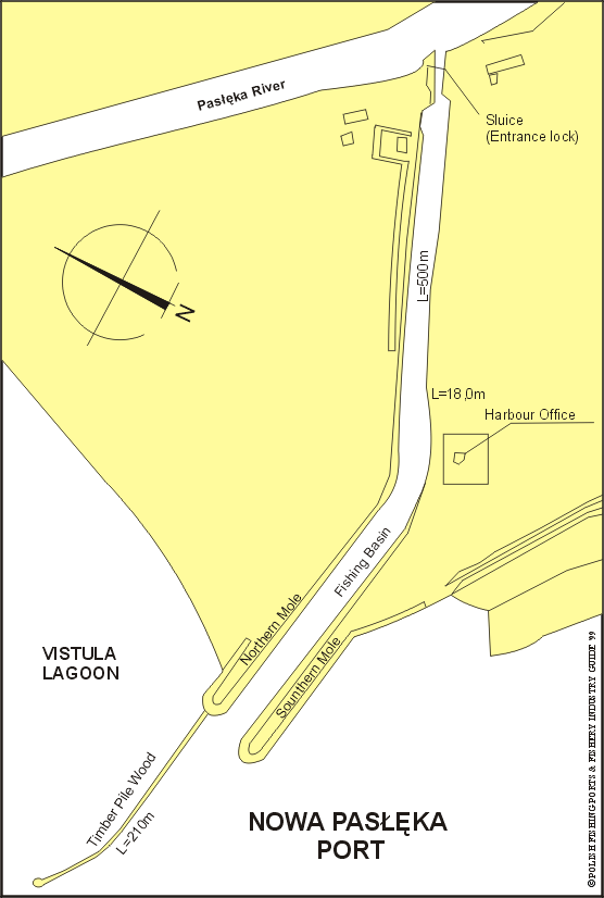
Nowa Pasłęka Light (grey metal framework tower, 6m in height,
topmark, white triangle, point up, horn frog signal) is exhibited
at the head of the S mole. The buoyed fairway approaches, about
30m wide and with a depth of 1.5m, leads SE from PASL Buoy,
1.25 miles NW of the harbour entrance.
Quayage and berthing facilities
Two short moles shield the harbour. The northern mole is length
by wooden-stony stockade, 210m long. Fishing harbour creates
port channel, 600 m long with two quays. The depth in the harbour
of 1.2 to 1.5m. There is entrance lock to the harbour from the
side of Pasłęka River.
General facilities
Fuel
Available.
Water
Available.
Slipping
Slipway for fishing boats.
Stevedoring
Available.
Fisheries facilities
Ice
Production plant of 25t per day capacity.
Cold storage capacity
Not available.
Chilling storage capacity
Chilling rooms for 50t of fish.
Frozen fish transport
Not available.
Types and size of fishing fleet
36 fishing boats, mainly laminate, with average length of
8.1m and average engine power of 49 to 82 HP
Types of fish landed (in tonnes) (1995)
VISTULA LAGOON:
Herring
460.8
Eel
27.4
Pike-perch
18.2
Perch
4.1
Sabrefish
3.8
Roach
3.7
Bream
3.5
Lamprey
1.7
Flounder
0.7
Others
0.4
Total
542.3
Nearest airport:
Rębiechowo, approx. 130km
Other info:
Substantial part of caught eel has been exported to
West-European countries as an alive fish.
General information:
Nowa Pasłęka is a fishing settlement situated on the southern
shore of Vistula Lagoon, 2 miles from the national border. The
harbour lies on the south-west bank of Pasłęka River and is
connected to the settlement of Stara Pasłęka on the north-east
bank via a bridge across the river. The small community of Nowa
Pasłęka is engaged in the main, in fisheries. Braniewo, about
4.5 miles from the mouth of Pasłęka River, which may be reached
by small craft, is connected to the general railway system.