Shop    |  Site map    |  Contact   
 
Maritime
Companies
Database
3698 addresses
 
Log in
 
Distances between portsDistances between ports
Inland WaterwaysInland Waterways
Inland PortsInland Ports
NavigationNavigation
on Odra River
on Warta River
 

  Inland shipping

You can click on some part of this picture to see his magnify.


The following provisions regulate the inland navigation on the Odra river:

  • The Act on Inland Water Transport of 21 December 2000 (Official Journal of Laws No. 01.5.43, 24 January;
  • The Regulation of the Minister of Infrastructure of 28 April 2003 on Navigational Regulations on Inland Waterways (Official Journal of Laws No. 03.212.2072, 15 December 2003)
  • The Regulation of the Council of Ministers of 7 May 2002 on the Classification of Inland Waterways (Official Journal of Laws No. 02.77.695, 18 June 2002);
  • The Regulation of the Inland Navigation Office Director of 12 June 2001 on Navigation on the Border Waters of the Odra, Western Odra and Lusatian Neisse (Official Journal of the West Pomeranian Voivodship No. 21/2001, item 433);
  • The Regulation of the Inland Navigation Office of 7 June 2004 on Local Regulations on Inland Waterways;
  • The Regulation of the Council of Ministers of 23 December 2002 on the Borders between Inland Surface Waters, Internal Sea Waters and Territorial Sea Waters (Official Journal of Laws No. of 31 December 2002).
    The above-mentioned extract of regulations refers to the movement on the Odra's inland waters from the mouth of the Nysa £u¿ycka river to the borders of inland thoroughfares with internal sea waters (to 36.55 km of the Western Odra in Szczecin - Trasa Zamkowa bridge - and to the exit from the D±bie Lake on the Szczecin-¦winouj¶cie thoroughfare through the Babina and Iñski Nurt).

Distances

A distance table of ports between Szczecin and other inland Polish and Western European ports, showing possible inland connections (see enclosed map and table).

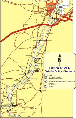
The length of the Odra in kilometres begins from the mouth of the Opava river in the Czech Republic (0 km) and continues downstream. Kilometre marker boards with even values on the right-hand side of river and odd on the left-hand side, half kilometres not being marked.

The above-mentioned stretch of waterways includes:

542.4 km - the mouth of the Nysa £u¿ycka; the Odra river becomes the frontier river between Poland and Germany,

553.4 km - Eisenhüttenstadt; the Odra - Spree Canal,

584.1 km - S³ubice and Frankfurt /Odra,

617.6 km - Kostrzyn/Odra; the mouth of the Warta, waterway Wis³a - Odra,

667.2 km - Hohensaaten; the Odra - Havel Canal,

697.0 km - Ognica, Schwedt Canal, which connects the Odra with the Hohensaaten-Friedrichsthaler Wasser-strasse lateral canal,

704.1 km - the Odra splits into the Western Odra and the Eastern Odra. The Polish national border passes from the Odra river onto the Western Odra. At the 17.1 km marker of the Western Odra the border passes onto land. A valve weir which prevents navigation from the Odra to the Western Odra is located at kilometre marker no. 0.0 on the Western Odra river,

730.5 km - the Klucz-Ustowo ditch, which connects the Eastern Odra with the Western Odra. Downstream of the ditch the eastern arm of the Odra changes into the Regalica river,

739.6 km - the eastern connection with the port of Szczecin through the Parnica river,

741.6 km - the mouth of the Regalica to the D±bie Lake,

3.0 km on the Western Odra - the mouth of the Hohensaaten-Friedrich-sthaler Wasserstrasse canal,

36.55 km on the Western Odra - the border of inland waters with internal sea water.

Navigation of water levels

  • The draught for vessels is dependent upon the present transit draughts which are given to the Inspectorates of Inland Shipping and any other interested persons by the administration of the waterway, the Regional Water Management Office, Szczecin (Regionalny Zarz±d Gospodarki Wodnej, www.rzgw.szczecin.pl).
  • The hydrological information referring to the present transit draughts are announced by the Institute of Meteorology and Maritime Industry (Instytut Meteorologii i Gospodarki Wodnej), broadcast on Polish radio - Channel 1 from Warsaw, 225 kHz, 1155 hrs.).
  • A transit draught or a vessel draught is determined by the vessel size, the push-tow size or the composite unit size and the draught of the waterway. It should be:
    • for vessels which the draught is less than 140 cm:
    • proceeding up-stream ≥15 cm
    • proceeding down-stream ≥10 cm
    • for vessels which the draught is more than 140 cm:
    • proceeding up-stream ≥20 cm
    • proceeding down-stream ≥5 cm
    • for the vessels carrying dangerous goods the difference should be increased by a minimum of 20 cm, in addition to the above figures.
  • Inland shipping in high waters is subject to the following restrictions:
    If the water levels attain or exceed high-water mark I (WW¯ I) on the water gauges, the following shipping rules must be followed by the vessels:
    • equipped with efficient radiotelephones which ensure radiowatch for ship to ship communications (channel 10), and the reception of navigational information,
    • equipping with efficient radio receivers. In addition, the ship is forbidden to stop in the main waterways at night.
    If the water levels attain or exceed high-water mark II (WW¯ II) on the one of the pair of water gauges (border stretch of river), or high - water mark II (WW¯ II) on rest of internal inland waterways inland is forbidden. The vessel proceeding should call to the safe or proctected port before exceeding to the high-water mark or the high-water mark II.
    The high-water marks I and II (WW¯ I and WW¯ II) on the particulars water gauges are the following (border stretch of river) and high-water mark (remaining internal inland waterwayws):
Water-gaugesStretch of riverHigh-water mark IHigh-water mark II
Border stretch of Odra river
Eisenhuttenstadtfrom 542.4 km490535
S³ubiceto 586.0 km430475
Frankfurt/Odrafrom 586.0 km445490
S³ubiceto 617.6 km430475
Kienitzfrom 617.6 km495535
Gozdowiceto 667.2 km490530
Stutzkowfrom 667.2 km860920
Bielinekto 697.0 km540600
Schwedt - bridgefrom 697.0 km790
Widuchowato 704.1 km660
Border stretch of the Odra Zachodnia (Western Odra) river
Gartzfrom 0.0 km630
Gryfinoto 17.1 km600
Remaining inland waterways
WiduchowaOdra Wschodnia (Eastern Odra) from 704.1 km to 718.1 km660
GryfinoOdra Wschodnia (Eastern Odra) from 718.1 km to 729.9 km610
Szczecin - "Most D³ugi" (Western Odra)Odra Zachodnia (Western Odra) from 17.1 km to 36.55 km Parnica from 4.0 km to 5.6 km; Przekop Parnicki590
Szczecin - PodjuchyOdra Wschodnia (Eastern Odra) from 729.9 km to 730.5 km; Regalia from 730.5 km to 741.6 km610

Lying of vessels

  • The mooring and lying of vessels and other watercraft on the border section of Odra and Western Odra is only permitted offshore, nearest the state to which it belongs, and in designated places. The mooring and lying of vessels of other states are permitted onshore of the state conducting the inward passport control.
    A list of these points is stated within border regulations.
  • In the case of technical or unforseen problems or inconvenient weather conditions ships and other watercraft may stop at any place along the border waters but for no more than 8 hrs. If necessary, when the ship must lie longer, the relevant border guards must be informed immediately.
  • It is prohibited to stay without a pusher tug in the shipping lane, or to push barges and other crafts without a crew. An exception may be made for a barge staying during the provision time of the pusher tug refueling and resupplying water or food, but only during the day and after previous securing and markings of the barge has taken place.
  • The laying of ships at port is permitted only in appropriately marked places by the port administration.
  • Near the mouth of the Odra at Spree Canal the following rules must be followed to:
    • tow sets including more than one towed ship, going down-stream should stay on the left side of the Odra river above 552.9 km. Towed ships are to be brought into the canal one after the other.
    • the ships waiting for a free pratique into the canal should stay on the left side of the Odra river above 552.4 km or under 554.2 km.
    • tow sets may be united under 554.2 km of the Odra river.
  • Near the mouth of the Odra-Havel Canal arrangements and separations of sets may be done on the left side of the Odra river from 665.0 km to 665.8 km.

Difficulties in shipping

  • A ship with an overall length of more than 80 m, should have the observation station located at the fore part of its ship. Observers on board should have radio or phone communication or visual and verbal contact with the steersman.
  • Shipping at night is allowed on the grounds of a permit given by the Director of the Inland Navigation Office during specified times, on specified stretches and for specified ships.
  • On the Odra river from 542.4 km to 617.5 km, ships and sets proceeding down-stream may not be overtaken.
  • During the ice season, stretches of waterways are closed to inland shipping. The decision to open and close the inland shipping lanes is determined by the administration of the waterway in consultation with the Inland Navigation Office in Szczecin.


© LINK S.J. 1993 - 2024 info@maritime.com.pl